Mandated by the Fédération des Chasseurs de Haute-Savoie, the project team monitored the movements of two deer populations in the upper Arve valley and the Giffre valley. Around fifteen animals were captured and equipped with GPS collars.
GPS collars provide very precise data on the spatial behaviour of the animals, such as their areas of activity, the periods and intensity of habitat use and movement corridors. This technology is therefore extremely useful, and even essential, for determining how animals use space. It provides wildlife managers with a first-rate tool, enabling them to gain a better understanding of issues such as the impact of landscape fragmentation or weather conditions, the influence of hunting activities, the impact of recreational activities, and the importance of protected areas for the conservation of the species.
HEPIA was responsible for monitoring and analysing the GPS data collected during the study.
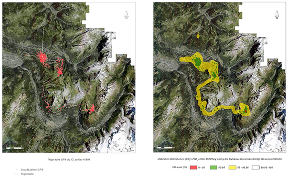
Maps from the CerArve deer monitoring project. They show the movements of one of the individuals over a 10-month period (left) and a space-use model (right).
Project partner(s)
Project leader - team
Claude Fischer
(HEPIA),
Laurent Huber
(HEPIA),
Loreto Urbina
(HEPIA),
Lucas Villard
(HEPIA),
Lula Golay (HEPIA)
